Enregistrez gratuitement cette image
en 800 pixels pour usage maquette
(click droit, Enregistrer l'image sous...)
|
|
Réf : T02258
Thème :
Terre vue de l'espace - Mers - Côtes - Caps - Péninsules (601 images)
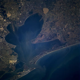
Titre : Galveston Bay, Texas, U.S.A. March 1996
Description : (La description de cette image n'existe qu'en anglais)
A shallow, sediment-laden inlet of the Gulf of Mexico, Galveston Bay is featured in this north-northwest-looking, low-oblique photograph. During the last ice age, when sea levels were much lower than now, the mouths of the Trinity River and the San Jacinto River extended southeastward into the Gulf of Mexico. The rivers’ estuaries filled and deposited sediment into a shallow basin that became Galveston Bay. As the ice melted, the sea level rose by almost 400 feet (122 meters) filling the present bay to an average depth of 12 feet (4 meters). The present mouth of the Trinity River (just below top center) is in Trinity Bay, upper Galveston Bay. The large sediment-laden, circular body of water east of the Trinity River mouth is Lake Anahuac. The former San Jacinto River estuary (below upper left) is now part of the Houston Ship Channel, which was completed in 1914. Reflective areas along the ship channel indicate numerous oil refineries and petrochemical plants. The completion of the Houston Ship Channel also included dredging a channel in Galveston Bay to the Gulf of Mexico 35 feet (11 meters) deep. Visible are Galveston on the eastern tip of Galveston Island and reflective oil refineries and petrochemical complexes northwest of Galveston in Texas City.
|
|

